Course Maps
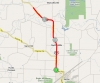
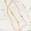
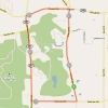
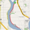
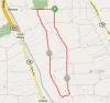
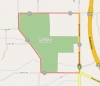
Akron, NY • Distance: 12.68mi • Elevation: 118ft
Course is a flat out and back with 180 degree turn around along state route 93. Take state route 5 towards Akron, NY. Turn North on state route 93. Parking is at Niagara Envelope located at North end of the village near corner of Hake Rd and Rt. 93.
...
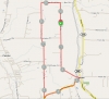
7844 N Pembroke Rd, Batavia, NY 14020 • Distance: 5.48mi • Elevation: 89ft
Flat course with quick laps Take Interstate 90 (NYS Thruway) to Town of Pembroke exit # 48A. Follow state highway 77 North to Phelps Rd. Take a right turn onto Phelps Rd and follow till road ends at a T intersection. Turn left and then first right onto Galloway Rd. Parking for the event is on Galloway Rd....
7844 N Pembroke Rd, Batavia, NY 14020 • Distance: 4.69mi • Elevation: 85ft
Flat quick lap Take Interstate 90 (NYS Thruway) to Town of Pembroke exit # 48A. Follow state highway 77 North to Phelps Rd. Take a right turn onto Phelps Rd and follow till road ends at a T intersection. Turn left and then first right onto Galloway Rd. Parking for the event is on Galloway Rd....
Arcade, NY • Distance: 9.62mi • Elevation: 246ft
From North, take state route 400 until it meets with state route 16. Follow route 16 south through the town of Chaffee. Park at The White Star Inn which is located on left just past Genesee Rd and Earl's. On race days we ride from the parking area to the start line. Distance approximately 2 miles.
From South, take state ...
Boston NY • Distance: 5.84mi • Elevation: 505ft
This course has one steep hill approx. 1 mile into the TT. The rest of the 5.84 mile course is rolling with a fast downhill section near the end. Recommended gearing is a 39x27. Take Route 219 south and get off at the Hamburg exit. Take Boston State Rd. Rt. 391, left until the signal at Boston State Rd. and Zimmerman. Turn right, go approx. 1/4 mile and turn left onto Back Creek Rd. Parking is at the Elementary School on your right....
Colden, NY • Distance: 10.48mi • Elevation: 669ft
Very fast Decent on Lower E Hill Road. Large hill climb on Cole Road. ...
Colden, NY • Distance: 6.97mi • Elevation: 243ft
Long straight flat sections with 2 climbs. After turn 1 you hit a steep climb for 1/4 mile, and after turn 4 it is about 1/2 mile at a moderate grade to the finish. From the North take Rte 219 to the Armour Duells exit and go right at end of exit ramp. Straight through light onto Rte 240, and then turn right onto Cole Rd. Left onto Old Lower East Hill, then right onto Lower East Hill at the 3 way stop. Parking at the Buffalo Ski Club 7595 Lower East Hill Road Colden NY 14033...
Buffalo, NY • Distance: .5mi
From the south, take the Rt 190-north and exit at Hamburg Street. Turn right on Hamburg St. and head south (towards the waterfront) to Perry St. Turn right on Perry St. and head west approx. 1/2 mile to the course.
From the north, take the Rt 190-south and exit at Louisiana Street and continue onto Scott Street to the course approx. 1/4 mile west.
...
Colden, NY • Distance: 4.75mi • Elevation: 232ft
Boston Colden Short course but uses Omphalius in place of Wolheuter. 1 moderate climb just prior to finish. ...
Orchard Park NY • Distance: 5.54mi • Elevation: 325ft
Short circuit type loop with one short yet steep climb, one long moderate climb and a fast downhill section. Recommended gearing 39x25. Take Route 219 South and get of at the Amour Duells exit. At Armour Duells and Rt. 277, make a right. Take approx. 1 1/2 miles until you see the entrance to Chestnut Ridge Park on your right hand side. You will then head into the main entrance to the park and use the main parking area. ...
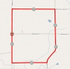
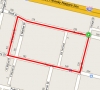
Clarence, NY • Distance: 5.6mi • Elevation: 29ft
Flat training course. Parking at St Pauls 7700 Goodrich Rd, Clarence Center, NY 14032 ...
Eden NY • Distance: .91mi • Elevation: 413ft
Tough, uphill climb. Approx. .75 mile climb, with steady grade of 15%.
Recommended gearing......... LOW!!!! Take Route 219 South, and get off at the Hamburg exit. Go right on Boston State Rd. Rt. 391. Go into the Village of Hamburg and take Rt. 62/Rt. 75 heading into Eden. Where 62 and 75 split, take Rt. 75 south. Go approx. 3-4 miles to New Oregon. Make a left. Start will be on New Oregon just past the intersection of New Oregon and Clarksburg.
Parking will be on Rt. 75 before you get to New Oregon. Park at the baseball diamond on the right si...
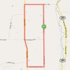
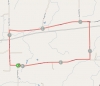
Corfu, NY • Distance: 6.1mi • Elevation: 171ft
Flat course, fast laps. From North: Take Interstate 90 (NYS Thruway) to Town of Pembroke exit # 48A. Follow state highway 77 South. Follow route 77 through traffic light and into Village of Corfu. Parking is at middle school located on the right just before traffic light for state highway 33. On race days we ride from the parking area to the start line. Distance approxima...
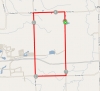
Corfu, NY • Distance: 4.51mi • Elevation: 145ft
Flat and fast laps. From North: Take Interstate 90 (NYS Thruway) to Town of Pembroke exit # 48A. Follow state highway 77 South. Follow route 77 through traffic light and into Village of Corfu. Parking is at middle school located on the right just before traffic light for state highway 33. On race days we ride from the parking area to the start line. Distance approxima...
Arcade, NY • Distance: 7.8mi • Elevation: 296ft
Everyone will ride as a group from the parking area to the course, and race will begin when each group gets to the corner of East Arcade Rd. and Allen Rd. Finish is on Allen Road just past Sullivan Rd. Parking at Steel & OBrien 7196 Route 98 Arcade, NY 14009 ...
• Distance: 7.72mi
Copy & Paste this link into your browser
http://mapq.st/16HwZwy
Rte 400 to Rte 16 South. Left (East) on Genesee, parking at Steel & O'brien at intersection of Genesee & Rte 98. Neutral ride to Allen Rd where course will start...
155 Knox Rd East Aurora NY 14052 • Distance: 6.7mi • Elevation: 178ft
Parking in the park lot on Knox, S/F about 1/2 mile west...
East Aurora, NY • Distance: 25mi • Elevation: 865ft
Race starts in Fisher Price parking lot and rides to official race loop.
Races turn back up Two Rod Rd to continue on for multi-lap fields. Finish is on Two Rod Rd.
...
Boston, NY • Distance: 9.45mi • Elevation: 700 feetft
...
Boston, NY • Distance: 6.2mi • Elevation: 144 feetft
...
Grand Island, NY • Distance: 1.2mi • Elevation: 17ft
Flat circuit course for training races. Parking either at Beaver Island Park or Beaver Island Boat Launch on East River Rd ...
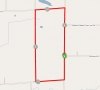
Grand Island, NY • Distance: 12.48mi • Elevation: 151ft
Flat Out and Back.
From the south, take Rt. 90 or Rt. 290 to the Rt 190 north. Take the Rt. 190 to Grand Island and take the Long Rd. exit at the north side of the island. Turn left at the exit onto Grand Island Blvd. and then turn left again onto Long Rd. Take Long Rd. to where we park at 2770 Long Rd, Grand Island NY 14072 the offices of GP:50 just up the road on th...
Grand Island, NY • Distance: 20.5mi
From the south, take Rt. 90 or Rt. 290 to the Rt 190 north. Take the Rt. 190 to Grand Island and take the Long Rd. exit at the north side of the island. Turn left at the exit onto Grand Island Blvd. and then turn left again onto Long Rd. Take Long Rd. to where we park at 2770 Long Rd, Grand Island NY 14072 the offices of GP:50 just up the road on...
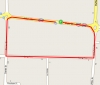
LeRoy, NY • Distance: 8.28mi
...
Arcade, NY • Distance: 8.86mi • Elevation: 351ft
Rolling course with mild hills. High speed descent into a turn going from Edmunds on to Maple Grove. Take Rt. 16 south passing through Arcade, then through Yorkshire, passing Rt 39, into Delevan. Take a left at Church Street, which is the ONLY light in Delevan. Church Street turns into California Hill Road and you continue until you see Bixby Hill Rd. Make a right onto Bixby Hill Rd. and stay on until you hit County Route 21. Just straight ahead is Railroad St. which is immediately after a farm. Parking / Registration is on Railroad St. Start/Fi...
Hamburg, NY • Distance: .7mi
Directions: Take the NY State Thruway Rt. 90 and take exit # 57 (Rt. 75/Hamburg). Take Rt. 75-south. (Rt. 75 is Camp Rd. which will then become Lake St.) Proceed south 2 miles to...
S-6765 Taylor Rd., Hamburg, NY 14075 • Distance: 14.66mi • Elevation: 586ft
Directions: Take the NY State Thruway Rt. 90 and take exit # 57 (Rt. 75/Hamburg). Take Rt. 75-south. (Rt. 75 is Camp Rd. which will then become Lake St.) Proceed south 2.2 miles to Main St/Rte 62 and turn left (east). Go about 1 mile and at the 2nd roundabout take the right onto East Eden Rd. About 1/2 mile turn left on Taylor Rd, parking and registration at Taylor Rd Park 1 mile down. From Canada: Take the QEW to Ft. Erie and cross the Peace Bri...
Hamburg, NY • Distance: 5.11mi • Elevation: 128ft
...
Hamburg, NY • Distance: 7mi
Starts and finishes at the Hamburg Recreation Center and features two turn-arounds.
Take the NY State Thruway Rt. 90 and take exit # 57 (Rt. 75/Hamburg). Take Rt. 75-south. (Rt. 75 is Camp Rd. which will then become Lake St.) Proceed south approx. 2.2 miles and turn right at the traffic signal to stay on Rt. 75, and then take the next right (west) onto Evans Street. (Evans Street turns into Lakeview Road) Go approx. 2.5 miles...
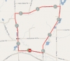
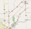
East Aurora, NY • Distance: 14.38mi • Elevation: 614ft
Long climbs, Some steep up hill and fast down hill sections. Event usually follows the following route - Hunters Creek Rd, right on Vermont St, right on Vermont Hill Rd, right on Centerline Rd, right on Hunters Creek Rd. One lap equals approximately 14.5 miles. Take state highway 400 to the US highway 20A exit. Turn left or East on US 20A and follow road to state highway 78. Turn right on state highway 78 and then right again onto Hunters Creek Rd followed by a right on Centerline. Parking is in gravel lot for Hunters Creek Park located just after the downhill at11830 Center Line Rd, South Wales, NY 14139...
Wales, NY • Distance: 9.6mi • Elevation: 600ft
1 possible route to shorten if needed ...
2982 Shirley Road North Collins, New York 14111 • Distance: 9.7mi • Elevation: 266ft
Take the Rt 219 and exit at Genesee Road. Turn right and head east on Genesee Road for approx. 6 miles to Sisson Road / Rt. 75 and turn right. Head north on Sisson Road for approx. 1.5 miles to Shirley Road and turn left. Take Shirley Road past Jennings Road and continue on until you come to the highway department garage on the right-hand side and park. Alternately take Rte 75 South from the I-90 Hamburg exit and turn right on Shirley Rd (about ...
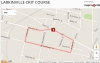
785 Seneca St Buffalo, NY 14210 • Distance: .80mi
Fast crit course on closed roads with great spectator amenities Larkin Square is centrally located in the Larkin District, just 1 block north of the Larkin at Exchange Building, at the intersection of Swan and Seneca Streets.
From Downtown Buffalo/WaterfrontDrive east on Exchange StLeft on Van Rensselaer St (Larkin at Exchange Bldg)Larkin Square will be on your right
From 1-190 Smith Street Exit 4 North on Smith St toward Seneca St Left on Seneca St Larkin Square will be on your left...
5397 Ida Park N Lockport, NY 14094 • Distance: 0.9mi
Course is flat and fast. Take route 990 to the French Rd exit. Turn left on French and then right on Rte 270 Campbell Blvd. Campbell becomes Rte 93 Lockport Junction Rd. After 1.8 miles turn right onto Upper Mountain Rd then Right onto IDA Park Drive....
5138 Lower Mountain Road Lockport, NY 14094 • Distance: 6.15mi • Elevation: 223ft
Rolling course with a small climb near start. Parking at Freedom Run Winery, Lockport NY5138 Lower Mountain Road Lockport, NY 14094. Take route 990 to the French Rd exit. Turn left on French and then right on Rte 270 Campbell Blvd. Campbell becomes Rte 93 Lockport Junction Rd. After 2.3 miles turn left onto Town Line Spur then left onto Lower Mountain Rd. Freedom Run is on the left. Please park at far end of lot away from tasting room....
Marilla Town Park 2488 Eastwood Rd East Aurora, NY 14052-9648 • Distance: 9.43mi • Elevation: 637ft
https://www.strava.com/routes/5932431 ...
Marilla Town Park 2488 Eastwood Rd East Aurora, NY 14052-9648 • Distance: 7.4mi • Elevation: 294ft
Parking located at Marilla Town Park
...
Marilla Town Park 2529-2999 3 Rod Rd, East Aurora, NY 14052 • Distance: 7.1mi • Elevation: 221ft
...
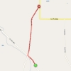
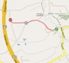
8019 Boston State Road Boston, NY 14075 • Distance: 1.32mi • Elevation: 607ft
Tough uphill TT with an average grade of 8.7% Parking at The Woodshed BBQ 8038 Boston State RoadHamburg, NY 14075 Take Rte 219 South to the Hamburg/Boston Exit. Left at Light onto Rte 391. Go approx 3 miles, Omphalius Rd is on left and The Woodshed is on right just past Churchill Methodist Church...
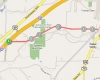
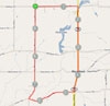
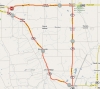
Pendleton, NY • Distance: 10.88mi • Elevation: 118ft
Get to Niagara Falls Boulevard. If you get there via the Youngman Expressway/Rt. 290, exit at the Niagara Falls Blvd. exit and head north. You will pass Ellicott Creek Road, Robinson Street, and then after approx. another mile, cross Tonawanda Creek. After crossing the bridge over Tonawanda Creek, you will exit at Connecting Road. That is the actua...
Boston, NY • Distance: 5.53mi • Elevation: 358ft
One very steep climb on Rice Road. Short laps. Take US Highway 219 to the Rice hill road Exit. Turn right onto to Rice Hill Rd and take first left onto Zimmerman. Take first left off Zimmerman on to Pfarner (across from fire station) and park. DO NOT PARK IN THE FIRE STATION LOT....
Boston, NY • Distance: 8.58mi • Elevation: 575ft
Parking is same as Rice Rd course
https://www.strava.com/routes/9671291 https://www.strava.com/routes/9671291...
Sprague Brook Park 9674 Foote Rd | Glenwood, NY 14069 • Distance: 8.91mi • Elevation: 440ft
Rte 219 to Genesee Rd Exit, left on Genesee. 3.7 miles to Rte 240, then left 2.4 miles to Foote Rd. 1st park entrance, park in the lot directly ahead near shelters 2/3, restrooms, and playground. Ride as group neutral to start/finish at Foote & Pratham....
Boston, NY • Distance: 1.5mi • Elevation: 541ft
An uphill climb commonly used for a mid-summer time trial. Take Rt219 to Rice Road. East on Dodge Rd which turns into West Tillen. Take West Tillen about 2/3 of the way down the hill. Take a left onto Mill Street. Park at the Fire Hall....
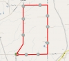
Clarence NY • Distance: 5.27mi • Elevation: 49ft
...
Wales, NY • Distance: 26.57mi • Elevation: 1168ft
Large course, 1 lap. Busy Roads with wide shoulders. Take US Highway 400E to the 20A Exit in East Aurora. Take 20A East. Just after woodchuck road at the top of a hill on the left will be the EverFab building with parking lot. Race starts there....